/137.59157180786,36.576111049813,9/397x132?access_token=pk.eyJ1IjoiamFwYW50cmF2ZWxtYXBzIiwiYSI6ImNqbXBtOXYxbDB5Z3ozbHFrazJuYWMwOGYifQ.v15fy_mcFWtgopmz8PhwqA)

Activities
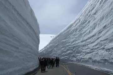
Toyama's Snow Wall
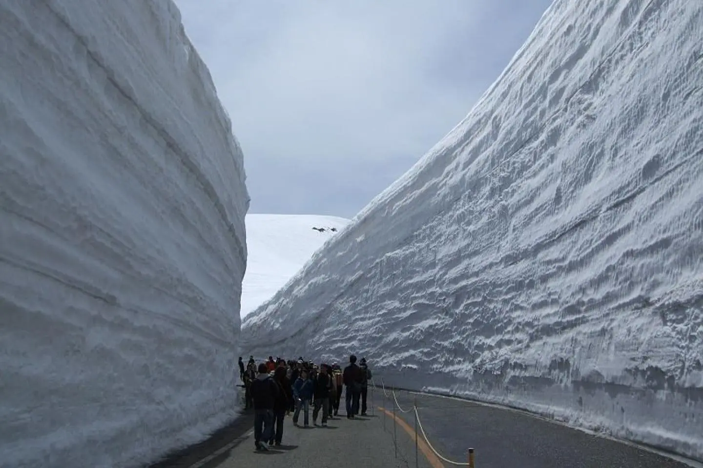
Sheila BurtToyama’s Yuki-no-Otani officially opens to the public in the spring, with snow walls approaching 20 meters in height.
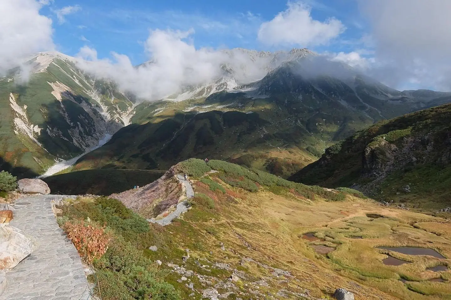
Opened in 1971, the Tateyama Kurobe Alpine Route is a mountain sightseeing road that connects Toyama and Nagano Prefectures. Despite being only 37 kilometers (23 miles) long, the route has several scenic stops along the way as well as hiking trails. From the top of the mountain, it’s even possible to see Mount Fuji on a fine day.
Hours of access change each season, please check their homepage for current hours of operation.
There are five different ways to traverse the alpine route, by funicular, bus, trolley, aerial tramways, and walking. It is important that no private transportation uses the route so that exhaust fumes do not harm the snow tunnels. During summer, shuttle buses also run between Toyama and Murodo.
Closed annually from December to mid-April for its deep and inaccessible snows, the main attraction of the Tateyama Kurobe Alpine Route is the scenery provided by the Tateyama Mountain Range, which is part of the Chubu Sangaku National Park. From mid-April to late June the snow corridor, a snow wall that reaches 15 to 20 meters high, becomes a visitor-favorite vista.
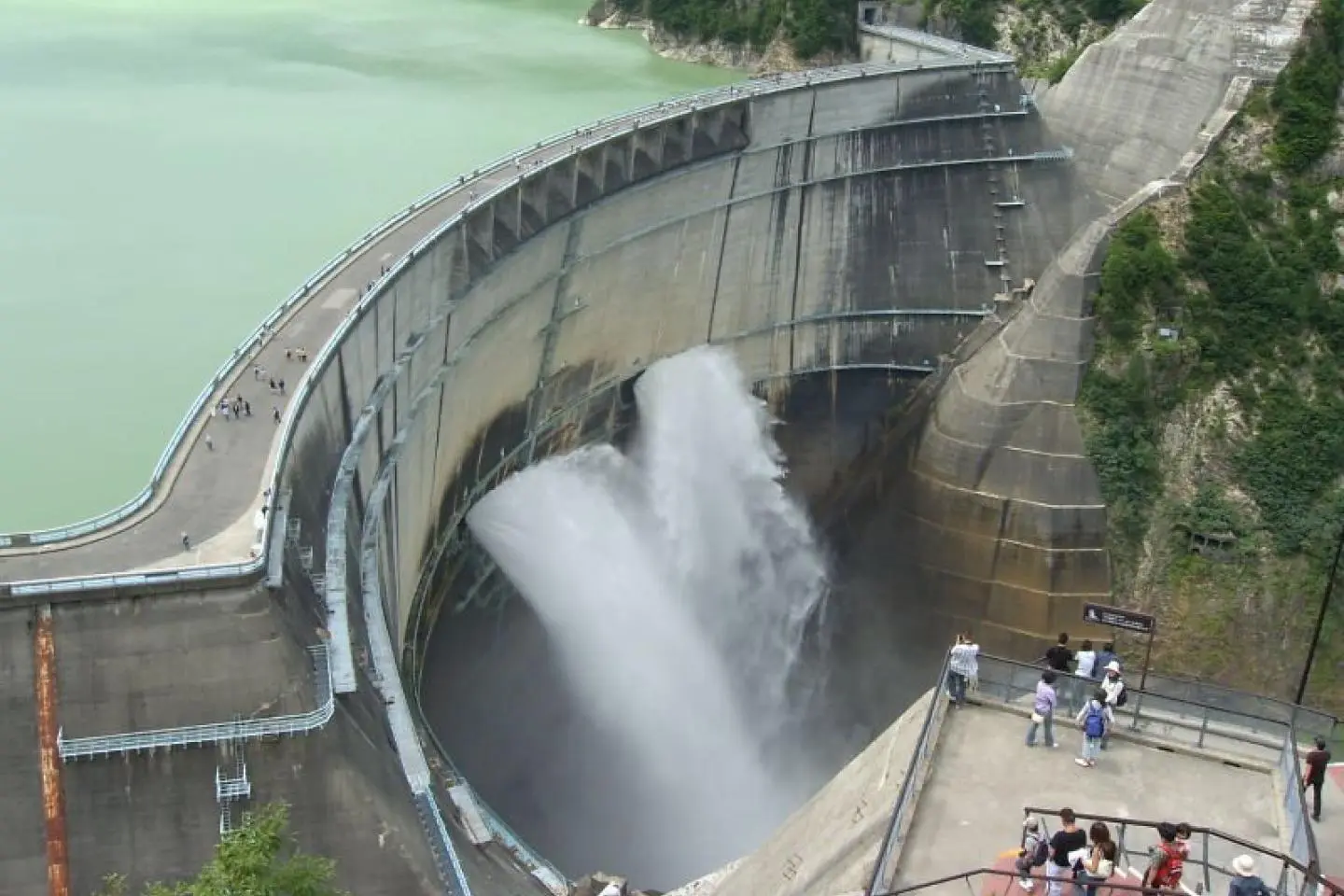
The rest of the year, the route remains a beautiful spot to see autumn leaves via the various hiking trails. And even offers a pathway to visit Kurobe Dam, which discharges water between late June and mid-October.
The Tateyama Snow Corridor is a giant snow wall that can reach heights of up to 20 meters. It is visible from April to June
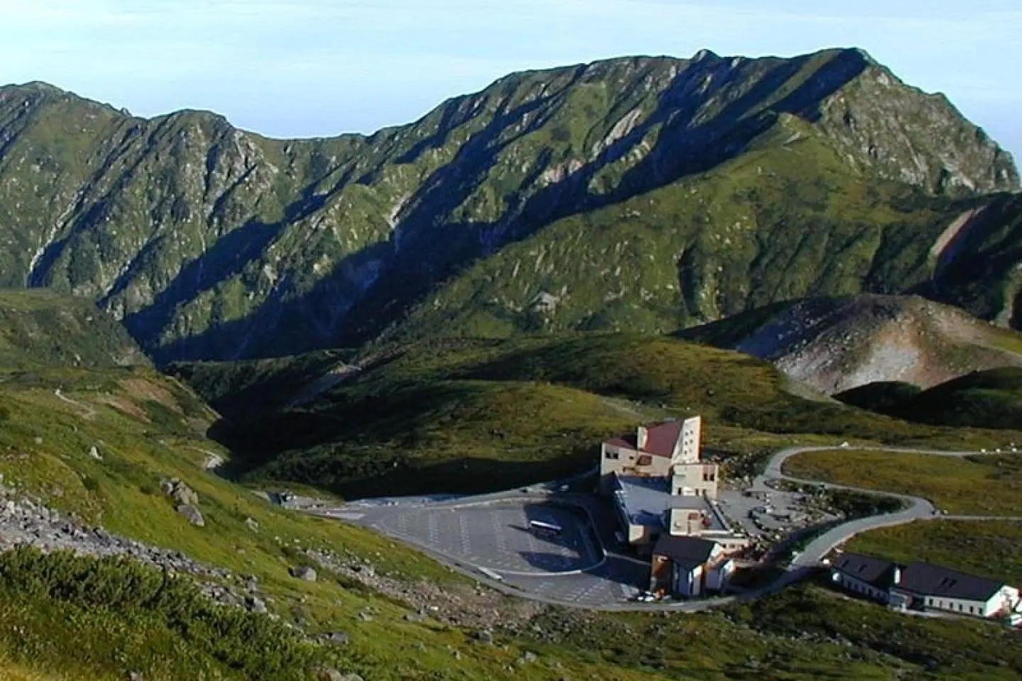
This secluded station connects to the alpine route via trackless trolley and bus. It's a beautiful sight in any season.

Exceptionally beautiful and intimidating with its size, the Kurobe Dam expels water in autumn and makes for a great vista.

Transportation departs from Ogizawa or Tateyama stations.
Toyama’s Yuki-no-Otani officially opens to the public in the spring, with snow walls approaching 20 meters in height.

Toyama’s Yuki-no-Otani is open from around mid-April until early June. The walkway closed June 10th for 2012, but you can stilll enjoy snow there in June around Murodo.
ยูกิ-โนะ-โอทานิของโทยาม่าเปิดให้ผู้คนทั่วไปเข้าชมในฤดูใบไม้ผลิ ที่มีกำแพงหิมะสูง 20 เมตร

The Tateyama Kurobe Alpine Route is an incredible and scenic route through the Northern Japanese Alps.

Early fall colors along Tateyama Alpine Route on a rainy day. Bathe in nature traveling via various transportation modes along Tateyama Alpine Route.

ใบไม้เริ่มเปลี่ยนสีที่ Tateyama Alpine Route ในวันฝนพรู อาบธรรมชาติโดยการเดินทางในวิธีที่หลากหลาย
도야마의 눈 벽은 매년 4월 중순부터 6월 초까지 방문객들을 위해 열린다. 6월에 눈 벽 사이를 걷는 길은 닫히더라도, 무로도 주변에서 여전히 눈 구경은 할 수 있다.
توياما مفتوح من منتصف أبريل حتى بداية يونيو . الممشى مغلق 10 يونيو لعام 2012 ولكن يمكنك التمتع بالثلوج هناك حول محطة مورودو

Mount Tateyama – one of Japan's three Holy Mountains
Yukami-no-Otani Toyama dibuka dari sekitar pertengahan April hingga awal Juni. Jalur pejalan kaki ditutup tanggal 10 Juni, namun kamu masih dapat menikmati salju bulan Juni di sekitar Murodo.
Yuki-no-Otani ที่โทะยะมะ เปิดให้บริการตั้งแต่ประมาณกลางเดือนเมษายนถึงต้นเดือนมิถุนายน ในปี 2012 เส้นทางเดินจะปิดในวันที่ 10 มิถุนายน แต่คุณสามารถเดินชมในพื้นที่อื่นๆ ที่มีหิมะได้ตลอดเดือนมิถุนายน

Highlights of the Tateyama Kurobe Alpine Route

Sắc Thu đầu mùa tại cung đường Tateyama Alpine vào ngày mưa. Du lịch hòa mình với thiên nhiên bằng nhiều phương tiện dọc theo cung đường Tateyama Alpine
Découvrez les sites phares de la route alpine Tateyama Kurobe !
Bức tường tuyết Yuki-no-Otani của tỉnh Toyama mở cửa từ giữa tháng 4 đến đầu tháng 6. Con đường đi bộ đóng cửa vào ngày 10 tháng 6 đối với năm 2012, nhưng bạn vẫn có thể tận hưởng tuyết ở đây vào tháng 6 ở quanh Murodo.
Toyamas Yuki-no-Otani ist von etwa Mitte April bis Mitte Juni geöffnet.
"Юки но отани", расположенный в Тояме, открыт для посещений с середины апреля по начало июня. В 2012 дорога закрылась 10 июня, но вы все равно можете насладиться снежными красотами близ Муродо до конца июня.

Rachiozawa Campsite is the perfect place to rest after hiking in the Tateyama area

Kurobe Dam is Japan’s tallest dam at 186 meters high and 492 meters long. It’s located in Toyama Prefecture and supports a hydropower plant. Built between 1956 and 1963, the dam was a massive engineering feat at the time and cost 51.3 billion yen (142.5 million USD) to complete. Although many issues arose during construction, the dam now helps supply the Kansai region with electricity. Featured in many kaiju (monster) movies in the past, Kurobe Dam is also a popular tourist spot and the most popular hydropower site in Japan. Between late June to mid-October, the spillway is opened at various times during the day for nearby onlookers to witness. The dam spits forth more than 10 tonnes of water every second. Crossing the dam takes about 15 minutes by foot—however, those who make the trek are rewarded with various vistas of the dam and Kurobe Lake. Visit the eastern end of the dam and walk up the stairs there (220 steps and quite steep) to arrive at the observation deck and see some of the best angles of the dam.
Toyama’s Yuki-no-Otani is open from around mid-April until early June. The walkway closed June 10th for 2012, but you can stilll enjoy snow there in June around Murodo.
The Tateyama Kurobe Alpine Route is an incredible and scenic route through the Northern Japanese Alps.